National seismic hazard maps for the UK: 2020 update
Synopsis
 The British Geological Survey published the 2020 national seismic hazard maps for the UK in November 2020 to update the previous maps published in 2007. The work was partly funded by the Institution of Civil Engineers, and the sub-committee B/525/8 of the British Standards Institution provided the overall guidance on the design requirements for the seismic hazard maps and regularly reviewed its progress.
Two factors prompted the revision of the hazard maps for the UK. Firstly, since 2007, there have been significant advances in the methodology for seismic hazard analysis, particularly with respect to how ground motion and its uncertainties are modelled. Secondly, updated UK seismic hazard maps will be needed for use with the National Annexes for the revised edition of Eurocode 8: Earthquake resistant design of structures, which is expected to be published in 2025.
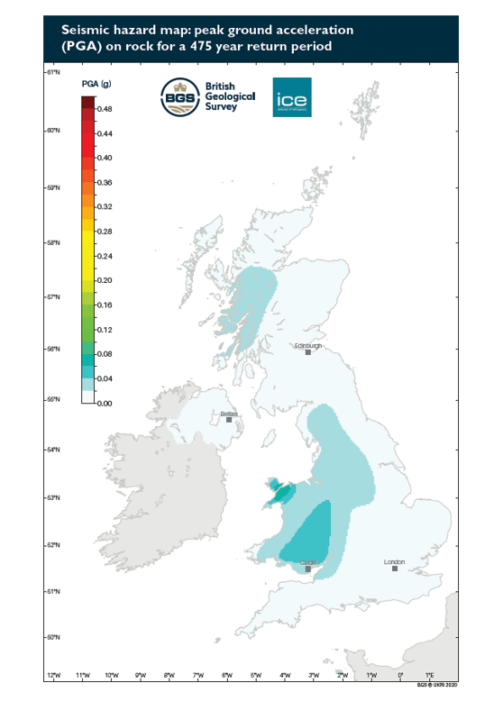
The 2020 national seismic hazard model accounts for: 1) the updated earthquake catalogue for the British Isles, 2) a thorough assessment of the catalogue analysis and the seismic source model, including the earthquake recurrence statistics; 3) the validation of the source model against the observed seismicity; and 4) advances in the ground motion modelling, including the host-to-target adjustments for the ground motion prediction equations used in the ground motion characterisation model. The national hazard maps cover the region between 49°N - 61°N and 8.5°W - 2°E and show peak ground acceleration and spectral acceleration at 0.2 s and 1.0 s for 5% damping on rock site conditions and for return periods of 95, 475, 1100 and 2475 years. The results confirm that seismic hazard is generally low in the UK and slightly increases in areas like Wales and north central England due to the higher rates of historical earthquake activity in these regions.
This talk presents the individual components of the 2020 national seismic hazard model, including the seismic hazard maps, how they compare with previous studies, and seismic hazard results for UK.
About the speaker
Dr Ilaria Mosca is a seismic hazard researcher in the seismology team of the British Geological Survey. She holds a Ph.D. in seismology from the University of Utrecht (the Netherlands) mapping seismic and thermo-chemical variations in the lower mantle using Monte Carlo approaches. After a PDRA in seismic tomography in Germany, since 2013 she has been working for BGS. Her work with BGS is on probabilistic seismic hazard analysis in terms of software and scientific developments, including catalogue analysis, ground motion modelling, and assessing realistic uncertainties for the various components of the hazard analysis, in the UK and worldwide.
Further information
This evening meeting is organised by SECED and chaired by David Hawthorn (BGS). Non-members of the society are welcome to attend. Attendance at the meeting is free. The meeting will take place online via Microsoft Teams*.
* Microsoft Teams is freely available on all major platforms, including Windows, Linux, MacOS, Android and iOS. To download and install the software, follow this link. SECED is not sponsored by or otherwise affiliated with Microsoft, and we do not endorse any Microsoft products.
Event Details
| Event Date | 26/05/2021 6:00 pm |